EWB-USA Philadelphia | Philippines Project

EWB-USA Philadelphia | Philippines Project
Engineers Without Borders USA - Philadelphia Professional Chapter | Travel Blog

Friday, December 28, 2012

Cultural Experience: The Food in Apatut and the Manila Fish Market


The food in the Philippines was FANTASTIC - abundant, fresh, and lovingly prepared.  In Apatut, there were new and interesting fruits and vegetables to try and tons of rice and fresh, locally caught fish.  Here are some photos of some of the fun and most interesting things we ate and one of my favorite places to visit, the Manila Fish Market.

Halo-halo (aka mix-mix)
A rice pudding dish

Fruit market


Gloria's Pancit - My favorite Filipino dish

Grapefruit

World's longest string beans

Where the magic happens - outdoor kitchenette

Fresh yellowfin tuna on our last night in Apatut

One of my favorite places to visit is the fish market in Manila - there are three locations, all similar.  Right next to the market are a bunch of hole-in-the-wall type eateries where you can bring newly bought fish or have them buy it for you and everything is made exactly to order.  I just love this idea and wish we had a place like this in Philadelphia!

Outside the market


Scallops in cheese and a buttery sauce

Shrimp in butter garlic sauce

Sweet and sour grouper

Crab
Happy eaters!

Everything, both in Apatut and Manila, was delicious, and definitely one of the highlights of the trip!

Team 2 arrives in Apatut


We arrived in Apatut at about 5 pm on a Monday night, after almost 36 hours of travel to get there (we had a brief respite in Manila between the 3-leg 24-hour flight and the 9 hour bus ride from Manila to Apatut).  Upon arrival, we learned just how busy Team 1 had been!  After a brief rundown of what had been completed to-date, we opted to split the team into two parts, with Steve, Anne-Marie, and Tiffini continuing with the community survey and Bob and Stephanie working on investigating potential water sources, including meeting well drillers, the local Balaoan Water District, and investigating wells in the community and the EWB drilled well.  

As previously mentioned, a water column was identified in the EWB well and was actually measured to be about 120 feet long (from approximately 10 to 50 meters below ground surface).  A recovery test was completed for the EWB-drilled well following the removal of approximately 6 feet of water column (removal was limited due to available equipment).  The well exhibited 'ideal', although slow, recharge, suggesting the potential for a sustainable yield for water supply.  Upon removal of piping, it was observed that the piping was covered with bentonite (a drilling material), suggesting that the well had not been properly developed.  

Villagers making pumping apparatus
The team collectively visited a neighboring spring site.  The site is owned and operated by the Balaoan Water District and, therefore, cannot be used as a water source for Apatut.  It was, however, a good opportunity to see and document the water source, and the visit cleared up some confusion about the spring based on previous trips.  


Spring Site


After Team 1 left, Team 2 completed additional sampling of the original locations for physical/chemical parameters and sampled the EWB well and all three wells at the school for biological, chemical, and physical parameters.  The results of the sampling confirm biological contamination and also identified some metals impacts above Philippine National Standards; these will need to be considered during the design phase.  As a result of interviewing several farmers in the community, EWB confirmed the use of herbicides and pesticides containing volatile and semi-volatile organics; this confirms the need for sampling of these parameters and EWB has been working to contract a lab with these testing capabilities in-country (only one lab has been identified to date).

Tiffini with sampling apparatus for the EWB well


Post-community meeting with volunteers


We also developed a detailed map of the school, canvassed materials suppliers in San Fernando, completed a chlorine treatment test, completed the community survey, and held community meetings.  


Tiffini scoping out a residential well
When all was said and done, EWB canvassed all occupied households in the community (over 175!) and was able to create a detailed map of the community identifying all relevant features including houses, latrines, wells, garbage pits, agricultural fields, roadways, etc.  EWB is working with a local college to have these locations surveyed and a to-scale map developed.  This was a huge undertaking and will be pivotal in our ongoing design efforts. 

Monday, November 12, 2012

Return to Apatut: Community and Well Assessment, Oct 27-Nov 5


The EWB-MAP team scheduled a trip to Apatut for additional assessments and investigations October 27-November 16; the trip was broken down in two phases, with four members arriving in Apatut October 29 (Walt Walker, Bob DiFilippo, Steve Kim, Anne-Marie Biser) and two additional persons arriving on November 5.  We arrived during the week of an important Filipino holiday (All Saints), which is something to take into account for future travel plans (encountering difficulty in meeting with certain persons or entities due to holiday closures)

Upon arrival to Apatut, we walked the community to get a visual feel of the area and some items which were previously GPS’d  earlier in the year by the team of Shelley/Ed. Upon general visual observation, It was also noted that most of the shallow wells in the community were sealed (hand pump), with the exception of those used for irrigation.

We viewed the proposed deep well site, observed some water in the well, which we eventually measured to be approximately 75 feet of water column.  Bob contacted a drilling contractor in Taguig City to visit and inspect the well as a viability of a community water source, or whether additional drilling would result in further attainment of water.

It was observed that the Irrigation wells (open holes, but pumped using generator) delivered a full consistent flow, estimated to be 30gpm; on other side of a street dividing the field a well/hole was hand drilled to a depth of approximately 40 feet, from which a similar flow of was noted.  One of the irrigation wells was on land donated to the chapter/community, although the distance from the main road and likelihood of nitrate and pesticide contamination raised some concerns. 

To further investigate the probably of using the shallow public wells a source, we sampled six (wells): one each from Robert Osoteo and a two neighboring houses (as a baseline) and three wells used for irrigation.  The samples were dropped off at the Department Of Science and Technology (DOST) in San Fernando on the morning we sampled (November 5). DOST is limited to testing of fecal coliform and was unable to test for other important parameters such as pesticides, turbidity, and TDS among others.   We are working to find the proper authorities to test for those items.

After walking through the community, we believed there are many more wells than what was shown on the Google Earth map. We concluded that an inventory/survey of the total number of houses and wells may be needed to get a better grasp on feasibility of alternative water distribution design options.  To use time efficiently in reaching out to all seven sectors of the community, the four of us separated into two teams (Walt/Steve, Bob/Anne) bringing along an interpreter for each team. The community survey focused on the source(s) of water for each household, and disposal locations of waste and grey water (important for examining potential groundwater contamination).


The second team of Stephanie Cook and Tiffini Smith arrived in Apatut on November 5, in hopes of addressing other issues such: tapping into the Province’s water main along the highway (household costs is a concern); status of the Water Cooperative (formed in 2010, is it still active?); investigation of the spring (in our survey, many households in Sector 4 admitted use for non-potable applications); additional well sampling for specific water quality parameters; and evaluation of a separate system for the elementary school.


Monday, July 9, 2012

Travels to Apatut: February/March 2012

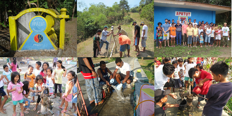
 I spent ten days living in Apatut, a small farming community in Balaoan, a municipality within the province of La Union, about 300 km northwest of Manila. Michael Baker Jr., Inc. sponsored me to travel to the Phillippines for EWB-MAP (Engineers without Borders Mid-Atlantic Professionals) to oversee well drilling and to prepare for later design stages of the project. The first phase of the project includes building a water supply tank, installing water treatment, and community tapstands. The second phase of design will be to extend the water supply line to the school and to each household. EWB-MAP plans to provide potable drinking water for approximately 750 residents and 300 school children who attend public school in Apatut.  The primary goal of the trip was to oversee the drilling of a well down to a deep aquifer to provide the community with clean water at a sufficient flow rate to meet daily demand.  All of the existing wells are only about 35 to 40 feet deep, pulling water from a shallow, contaminated aquifer. Many of the residents experience illness such as dysentery, diarrhea, and stomachache due to the poor quality of their drinking water. For now, they must boil water or buy bottled water in order to avoid contamination and illness.

Ed Jakubowski, another volunteer and a geologist with ERM, and I stayed in Robert Osoteo’s family house in Apatut. Robert along with Edgardo Ayaquil helped to start the Water for Life project with EWB in 2007. Robert’s parents were farmers and raised him and his siblings in the village. Though Robert and his wife and children live in Canada, he comes back to the Philippines each year to visit family and to progress the water project. 
For seven days, I visited the drill site each morning and evening to check on progress and to evaluate the soil samples taken at each meter of depth. The drill bit reached 100 meters during the second week of the trip. The following day, resistivity testing was performed to determine whether there was any hope of the well producing water. Disappointingly, the well was found to be dry, made up of 100m of clay and shale layers. The hardest part of the trip was meeting with the community leaders and seeing the disappointment on their faces as the team shared the outcome of the drilling. However, Ed and I reassured them that the EWB-MAP team was by no means giving up, and that we’d back with another plan in search for water. 

When it was determined that the proposed well would not provide an adequate water supply, additional data collection was initiated.  Over the last two days, the team surveyed all of the existing wells in the community, going door to door to speak with the families that own the wells. While some sectors of the village have wells for each household, there are large sections of town where the homeowners do not have individual wells on their property, and must share nearby wells with their neighbors.  Although some of this data was previously collected during the project assessment trip, the level of detail was increased to include collection of GPS coordinates, owner name, year built, well yield, etc. 

Also while in Apatut, we collected GPS data for the main supply trunk-line run along the main road as well as at the proposed water storage tank site, and proposed access road. We met with potential masons, obtained price quotes for materials to construct the water storage tank, and estimated the quantities needed for a smaller version of the tank that will be built to practice ferrocement construction techniques before building the full-size version for the project.

The EWB-MAP team plans to re-evaluate potential well-drilling sites in the village or other potential water sources in the project vicinity and gather additional geologic information for the area. All of the data collected from the trip will be processed and used to create a map of the area. The driller proposed to perform resistivity testing in the village to determine the next drilling location, however these tests can produce false positives thus are not foolproof. More sophisticated testing could be helpful for finding the best location to drill, however such tests can be expensive and may require skilled individuals to volunteer. Though the results of the drilling were unsuccessful, there are many other ways to approach the water problem in Apatut. Engineers are problem solvers, and are trained to persevere even when an immediate or easy solution is not at hand.